High-altitude wetlands [1] are critical ecosystems at risk from global climatic changes and local human activities. In the Indian subcontinent, they are reservoirs of biodiversity, providing rest sites for birds migrating across the Himalayas, and support many types of endemic wildlife. Human communities also inhabit the regions surrounding the high-altitude wetlands; they rely upon the ecosystem services [2] provided by these wetlands for their survival. The terrain is remote and inhospitable. Landslides and snowfall can block passes for days on end and temperatures can be extreme. Infrastructure development activities in the region such as road construction and the deployment of utility networks can benefit the local communities, but need to be environmentally sustainable. Mitigating the impacts of climate change is also required to ensure the continued existence of these wetlands. Developing best-practice management plans for the conservation of these biodiversity hotspots require accurate spatial information.
The overarching purpose of my research in the high-altitude wetlands of the Tso Kar basin in Ladakh is to collect spatial data from the local human community and assimilate it with data from other sources. Together, these datasets can be used to create a consolidated and dynamic atlas of the Tso Kar basin wetlands. The purpose of this atlas is to help stakeholders, such as the Changpa, make informed and accurate decisions regarding development activities in the Tso Kar basin.
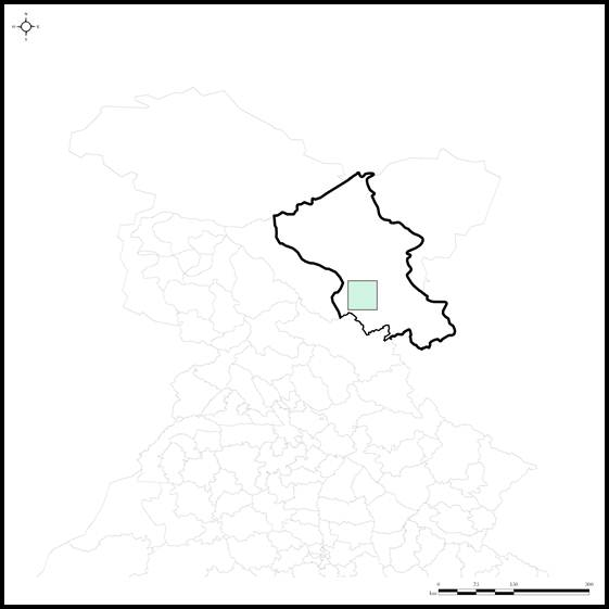
The Tso Kar basin is located at an altitude of 4500m in the cold deserts of the Changthang plateau in Ladakh, and contains two lakes. The smaller freshwater Statsaphuk Tso is connected to the larger eponymous brackish Tso Kar by a small channel, and both are surrounded by wetlands. The basin itself lies just off the Leh-Manali highway south of the Taklang La pass, and can be accessed by road through one saddle [3] in the northwest and another in the southeast. The wetlands surrounding the lakes in the Tso Kar basin host various species of wildlife, and are an important breeding site for the endangered black-necked crane (Grus nigricollis) in India.
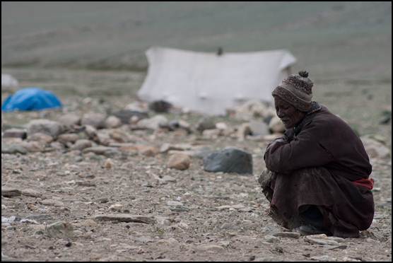
Stakeholders in the basin region consist of wildlife and wetland managers, administrative officials and the local human community known as the Changpa. The pastoral nomadic Changpa who live in and around the Tso Kar basin are completely nomadic. They move across the landscape with their livestock, stopping at pre-determined settlements for a few weeks at a time before moving on when they feel that their herds require higher grass densities. In summer, they live on the grasslands outside the Tso Kar basin, while they depend on the wetlands within the basin in the cold winters.
Two Army engineering divisions, the Border Roads Organisation (BRO) and the General Reserve Engineering Force (GREF), are implementing infrastructure development activities, such as road construction, within the basin. Other regional stakeholders include wildlife and wetland managers (such as the World Wildlife Fund), who act as representatives for the wildlife in the region; administrative officials (such as the Ladakh Autonomous Hill Development Council), who are decision-makers regarding development activities in the region, and law enforcers (i.e. the State Forest and Wildlife Departments) who are responsible for the enforcement of environmental law. Tourist agencies are also stakeholders in the future of the Tso Kar basin as the area is becoming a prominent destination for bird-watchers, outdoor enthusiasts and off-road vehicle drivers.
Mitigating conflict between these groups while preserving the ecosystems in the Tso Kar basin requires informed management. Spatial information is a primary requirement for such informed management plans. My project involved collecting and consolidating this information from various sources. While remote sensing data was obtained from dedicated online repositories [4], the Changpa community provided information regarding their resource use and movement patterns.
I chose cartographic representation as my mode of information collection from the Changpa since it bypasses issues of translation. Signs, symbols, points and lines do not require a language for explanation. The community's information was obtained through interactions with the individual members. Instrumentation such as Global Positioning System (GPS) devices and satellite imagery were used for data verification.
The Changpa claim traditional rights over the basin and the surrounding areas, by charging tourists a nominal fee for overnight camping and restricting grazing permissions to non-locals. However, no official land records validate their claims. Further, since the Indian Forest Rights Act (2006) is not applicable in Jammu and Kashmir, which includes this region, it does not provide the Changpa with any land rights. The Changpa also do not have access to spatial information via survey maps (restricted for reasons of national security [5]). They also do not have access to facilities such as the USGS Landsat imagery viewer or Google Earth because of the technological inaccessibility of these resources.
I believe that making this information about land-use and movement patterns of the Changpa available to all stakeholders, and opening up the data, serves a set of valuable functions. It will help law-enforcers, administrative officials and environmental managers make better decisions regarding conservation and development in the Tso Kar basin. Incorporating community land-use patterns and in a broader sense involving the communities most impacted by decisions in the decision-making process itself could lead to better and more representative governance. In lieu of land records, this information will allow the Changpa to defend their territorial claims over the region in the possible case of future conflicts with other stakeholders regarding land rights.
The challenge was to translate the Changpa community's view of their landscape into a structure that could be fed into a Geographic Information System (GIS), where it could be cross-referenced with remote sensing data [6] to add to its value. Remote sensing data can provide information on temporal land-use/land-cover change, vegetation and water availability, and the topography of the land. Mashing up remote sensing information with local community knowledge can help identify patterns and theories regarding future trends in resource use and possible stakeholder conflict.
To obtain spatial information from the Changpa community, I went into the field with a set of satellite images of the terrain, transparencies and marker pens, and met with groups of three to five community members at a time. I would identify certain points, such as our present location, other settlements or passes whose locations both the participants and I were familiar with. I then asked them to mark out important features, such as settlements or passes on the maps, as a brief training exercise in understanding the satellite image. One observation I made was that my informants had difficulties with estimating distances between points on the satellite images. They were better able to locate them using other known reference points. In other words, they were better at triangulation than at distance estimation.
Most of my informants had never seen satellite imagery of any sort before. However, they were familiar with maps and were able to make the spatial-cognitive leap to comprehending that the satellite images depicted an overhead view of their land. Once this idea had been grasped, they could begin to add additional layers of information to my satellite imagery, such as settlement locations, areas of resource use, time spent in each area, and the seasonal areal movement pattern.
All conversation was in Hindi, although at times my informants would argue with each other in their native Rupshu dialect of Ladakhi. Arguments were either about the location of a particular settlement, or about the time of the year at which they moved to a settlement. Participants would disagree about exactly where on the map a point was located, and would try and dominate the argument by referring to physical features on the map and using their information about the land to validate their claims. I resolved these arguments through field visits and the use of instrumentation to verify the ground truth. However, participants would disagree about the exact time at which they moved to a location, with their estimates varying by 10-20 days at a time. These discrepancies can be understood in light of the fact that the nomadic movement schedule changes annually depending on the availability of fodder. So a two-three week change in movement time from one year to the next is not unusual.
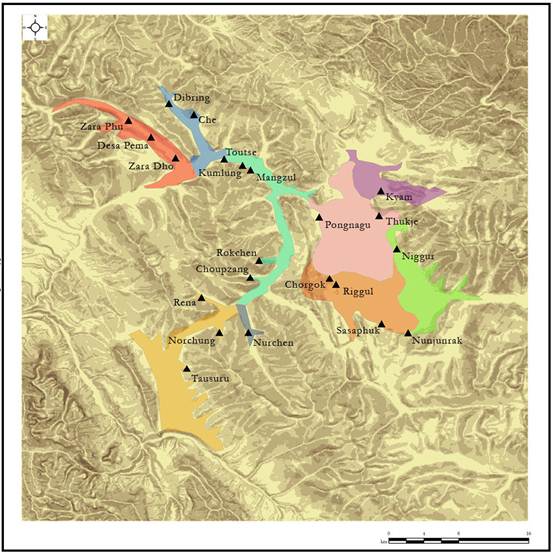
This process resulted in the creation of a series of distinct datasets. One was a text-only dataset that consisted of a table where the name of the region and the season it was used in was recorded. This information was collected through repeated interviews. Another was a text-spatial dataset where the name of the region was connected to its delineated borders as identified by the participatory mapping process. Finally, there was a spatial dataset consisting of settlement locations and road networks, obtained through field visits. By cross-referencing all these datasets, I had obtained information on the spatial movement and seasonal resource use of the Changpa in the Tso Kar basin. This information could be input into a GIS system, and overlaid on the remote sensing imagery to create an agglomeration of data, more poetically known as a data mash-up.
By collating information from various sources, I have described and delineated a nomadic community's resource use and movement patterns. This information product isIn iI accessible to a far wider audience than the Changpa. Academicians, decision-makers and conservation scientists can access this information in the form of physical maps or web-based systems. Most importantly, this spatial information can be mashed up with other data to help regional stakeholders, including the Changpa, make informed decisions that affect the future of these high-altitude wetlands.
The question now remains as to what use the Changpa themselves will make of this information. I believe that in the case of disputes about territorial rights, this will help them verify their claims over the land they control. They may also be able to use this information to design and implement community-based tourism activities, and to refine and articulate their position on development and conservation activities conducted in and around the Tso Kar basin. Over the next few years, I hope to help this nomadic community use and leverage the information they possess regarding this harsh and beautiful landscape to protect their natural heritage.
I would like to thank the WWF-India's High Altitude Wetlands Program for funding this study. I am also deeply grateful to Tharchen and his family in the Tso Kar basin for being such gracious and tolerant hosts.
Chambers, R. (2006). Participatory Mapping and Geographic Information Systems: Whose Map? Who is empowered and who disempowered? Who gains and who loses? The Electronic Journal on Information Systems in Developing Countries, 25(2):1-11.
Elwood, S. (2006) Critical Issues in Participatory GIS: Deconstructions, Reconstructions, and New Research Directions. Transactions in GIS, 10(5): 693 - 708.
International Fund for Agricultural Development (2009). Good practices in participatory mapping. Review.
Neefjes, K. (1993). Examples of Participatory Rural Appraisal in wetland development in Guinea Bissau. RRA Notes 17, pp.49-56, IIED London
Rambaldi et al. (2006) Practical ethics for PGIS practitioners, facilitators, technology intermediaries and researchers. Participatory Learning and Action. April 2006. 106-113
Wetland Action (2004). Participatory Methods in Sustainable Wetland Management. Report.
[1] High-altitude wetlands are defined as those wetlands found at or above 3000m in altitude. In India, high-altitude wetlands are found only in the Himalayas and the trans-Himalayan Tibetan plateau, in the state of Ladakh.
[2] Examples of wetland ecosystem services would be their capability to mitigate floods, increase the height of the groundwater table and provide breeding habitat to migratory waterfowl.
[3] A saddle is the low part of a ridge between two higher points or peaks.
[4] The online repositories used for this study are maintained by the University of Marylands Global Land Cover Facility (GLCF) and the Consultative Group on International Agricultural Research Consortium for Spatial Information (CGIAR CSI). While the GLCF hosts the Landsat archives, the CGIAR-CSI hosts the SRTM data, and allow both datasets to be freely used, with attribution for non-commercial purposes.
[5] Ladakh is a part of the state of Jammu and Kashmir. While the entire territory is claimed by India, Pakistan controls an area to the west and China holds a portion in the east. The Indian administration is very circumspect regarding spatial information about this region. Since most of this spatial information is available from sources based outside the country, the restrictions justified on grounds of national security handicap the local people who could make best use of it.
[6] Remote sensing data, in the broadest sense of the word, refers to data that has been collected from afar; telescopic imagery, aerial photography and satellite data could all be classified under this term. The information obtained through remote sensing techniques can be organised, arranged and analysed within a Geographic Information System (GIS). A GIS can be capable of handling many layers of information. In this project, the information obtained from the Changpa is merely another set of layers that can be compared with the layers of remote sensing information.